Locus Map 4 Outdoor Navigation v4.36.1 Build 1221[Silver]
Requirements: 7.0+
Overview: Locus Map is a multifunctional navigation app with offline maps for a fully enjoyable outdoor experience. Create, plan, edit, record, save or share your trips, keep the memories, track your performance, and much more. Locus Map is designed for hiking, mountain biking, cycling, running, geocaching, cross-country skiing, and other outdoor activities.
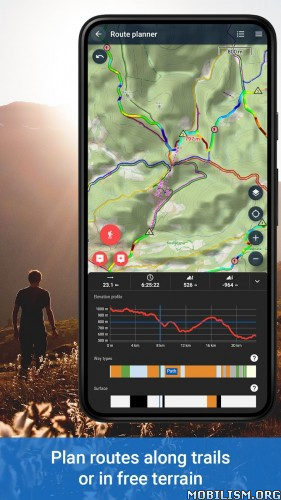
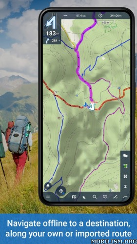
GPS navigation app for hiking, biking, geocaching and other outdoor activities.
More fun(ctions) for your adventures! Multifunctional navigation app with offline maps for a fully enjoyable outdoor experience.
Create, plan, edit, record, save or share your trips, keep the memories, track your performance, and much more. Locus Map is designed for hiking, mountain biking, cycling, running, geocaching, cross-country skiing, and other outdoor activities.
Fully customizable and flexible, offering a wide range of cool functions running above a variety of maps of the whole world.
Plan, record and manage your activities:
• plan routes along hiking trails, bike trails, or in an open terrain
• record tracks with all useful stats – distance, speed, pace, height gain, calorie burn, and other
• import and export the routes in various formats (GPX, KMZ, TCX…)
• share your tracks to Strava, Runkeeper, or Google Earth
• create your private database of interesting or favorite places
• browse your geotagged photos on the map
• import and export points of interest in various formats
Navigate and guide offline:
• turn-by-turn voice instructions or sound signals
• out-of route alert
• navigation and guidance along routes imported from elsewhere
• beeline guidance in an open terrain
Hunt for geocaches:
• download caches for offline play via G4L add-on
• navigate caches above the map or using the compass, log them online or offline
• use graphic and calculation tools
• manage your logs and drafts
• get alerted of an upcoming geocache
Customize your app:
• configure its main menu according to your actual needs
• set the main screen – function panels, right/left-hand control, light/dark mode…
• set coords system, units, dashboards and screens
• enjoy the app’s flexibility with the configuration presets
Use maps from our wide selection:
LoMaps – offline maps of the whole world
• switchable to hiking/biking map, winter or city map. Download 3 of them for FREE.
Outdoor maps by the world’s best cartographic publishers
• USA&Canada – USGS classic/satellite, AccuTerra trail maps, BackRoad Map Books,
• Europe – Ordnance Survey (UK), Kompass, Outdooractive, Freytag&Berndt (Germany, Austria, Italy), IGN (France, Belgium), CNIG (Spain), Lantmäteriet (Sweden), Kortforsyningen (Denmark), PZS (Slovenia), Compass (Poland), Swisstopo (Switzerland), SHOCart (Czechia, Slovakia) and many others…
• add external maps in SQLite, TAR, MBT, GEMF, Orux or RMA formats
Get even more with the Premium subscription
Go fully offline
• enjoy offline LoMaps of the whole world including updates without extra charges
• search offline addresses and LoPoints
• navigate and plan routes with the built-in offline router
• display elevation of any place on Earth without an internet connection
Keep synced
• use your tracks, routes, and points synced across multiple devices including web portal
Go web
• plan routes on a big PC screen, sync them with your mobile devices
• browse, view and manage your routes and tracks in a web library
Go live
• share your location in real-time with your family or friends in your own private groups
Sport packet
• connect the app with BT/ANT+ sensors
• work out with audio coach
• monitor your rides on a dashboard with handsfree screen control
Map tools
• calibrate map images
• overlay two various maps
• set map offset
And enjoy all other Premium features of the app
• 24/7 weather forecast on any place on Earth
• parking assistant
• no ads and LoCoin bonuses
App uses the Device Administrator permission
[color=green]Mod Info:
• Silver subscription is now open (and a little Gold)
• Unlimited tariff for downloading tiles is now open
• The ban on downloading satellite images has been lifted
• Account login is only possible via email!
[b][color=#008000]
What’s New:
Fixed: Crash when taking a photo with the camera on Android 17
Fixed: Crash when displaying the route graph on some older Android devices
Fixed: Crash on launch on the Moov Africa S100 phone
Fixed: Crash when exiting the app after viewing a large number of points
Fixed: Crash when moving the app to the background while map tiles were still loading
Fixed: Crash when opening a link from an email in an old Locus account
Fixed: Crash when pressing the back button while the point or route details were open on the map
Fixed: Crash when opening a point or route from the GPS/Compass screen or the Custom screen
Fixed: Android Auto reminds you to only look at your phone when it is safe, and the Premium version can only be opened while parked
Changed: Settings screens and their UI components have been redesigned based on a modern, easy-to-maintain system
Changed: The point details screen has been redesigned to match the route screen, making better use of space on larger screens
Added: (SILVER) Bosch E-Bike Support (Smart System) – Shows up in the list of auto-paired Bluetooth sensors and displays assist mode, motor power, remaining range, and accurate battery level, retaining your custom assist level names after reconnection
Added: (SILVER) Step Counter – Counts your steps using just your phone, with step count data included in exported FIT, GPX, and TCX files (and read in GPX imports)
Added: AR mode now also shows nearby places from LoPoints, so summits and landmarks are named even if they aren’t on the map
Added: Any point can now be shown in AR mode – select it in the point menu and it will highlight just like a navigation target
Added: AR mode now warns you when something nearby is distorting the compass readings or when the compass needs calibration
Added: An arrow on the edge of AR mode shows which way to turn when the target is off-screen
Added: in the mode menu In AR, you can hide your own map points or online LoPoints to see only one or the other.
Changed: Points in AR mode move smoothly to each new position instead of “jumping”; this is especially noticeable when you stand next to one.
Changed: Points in AR mode shrink more smoothly as they move away, so distant objects no longer appear the same size.
Changed: The screen no longer darkens when AR mode is open.
Fixed: AR mode waypoints now stay in the location they mark – on some phones they were moving a third further than they should have
Fixed: AR mode waypoints no longer lag behind the camera view when rotating the phone
Fixed: A closer waypoint in AR mode now appears on top of a more distant waypoint behind it
Fixed: AR mode no longer shows the map behind it momentarily when rotating the screen
Fixed: A crash when opening AR mode
Added: (GOLD) You can now hide path and surface type lines under the track graph
Fixed: The track editor could crash if the “Delete All Before/After” feature was expanded to the point where it deleted the entire track
Fixed: A crash when displaying a track graph or route with a flat value range
Fixed: (SILVER) A crash when opening track details from the dashboard after stopping recording
Fixed: Total ascent and descent values were too low on paused and trimmed routes Fixed
: When displaying ascent and descent for a selected waypoint, pauses in the recording were ignored and the last segment was not taken into account
Fixed: Ascent and descent statistics were understated on routes saved with the “Save Actual Leg” feature
Fixed: When calculating the climb and length of a route segment, the gap during a pause in the recording was taken into account
Fixed: When calculating the length and time of a merged track, pauses in the recording from the source tracks are no longer taken into account
Fixed: A pause in the recording located immediately next to another could disappear when trimming, splitting or merging a track
Fixed: When recalculating track statistics after editing details or updating the altitude, the pause in the recording could be displayed incorrectly
Fixed: (SILVER) route split (interval) distance and time could be incorrect for the segment immediately following a pause in the recording
Fixed: The altitude loss indicator remained empty in route statistics and in the route planner for routes with a descent of more than 1000 m
Fixed: The pause at the very beginning of the recording could be displayed as a solid line instead of a space
Fixed: Automatic pause of track recording did not work on Android versions 7–11
Fixed: Automatic pause of track recording could stop working until the application was restarted
Fixed: The “Insert/Edit Track Point” function no longer removes spaces from the edited part of the track
Fixed: The track line colored based on speed, incline, heart rate, or power drew a straight connecting segment between two adjacent gaps
Fixed: Track details no longer show outdated elevation gain/loss data after track elevation recalculation
Fixed: Waypoints (nav markers) could be displayed at the wrong distance along the route when exporting to FIT format
Fixed: Tracks without navigation no longer have two unnecessary start and end points added when exporting to FIT format
Fixed: Track graph was lagging on tracks with a very large number of waypoints
Fixed: Graph in the track recording panel was not responding to taps and drags
Fixed: Selected waypoint on graph was in the wrong position after returning from the graph screen
Fixed: Track editor – map stopped shifting for the bottom panel after the panel was hidden once
Fixed: Side menu remained open after opening track details from the track recording panel
Fixed: Text size could not be adjusted for graphs in the toolbar
Fixed: The “Waypoint line width” setting stopped working
Fixed: The app would sometimes lose maps, waypoints, and settings after restarting due to a silent switch to an empty storage folder
Fixed: Maps and national coordinates no longer shift by several hundred meters
Fixed: Purchased offline maps (e.g. IGN) no longer get stuck on the “expired subscription” placeholder while the subscription is still active
Fixed: Purchased offline maps could show tiles with the “unknown issue” message when starting the app without an internet connection
Fixed: (SILVER) WMTS map whose tile grid is described in degrees no longer remains blank
Fixed: Disabling “Keep map centered” after moving the map no longer causes the map to snap back to your location
Changed: Zooming with two fingers now keeps the map centered on your location
Changed: The map no longer snaps back to your GPS location while a route or waypoint is open over it
Fixed: Swedish maps “Lantmäteriet” load again on Android 13 and older
Fixed: When zoomed in to the maximum, the map no longer shows an empty vertical bar covering part of the screen
Fixed: The selected route could be shown as a solid white or black line when zoomed in to the maximum
Fixed: (SILVER) The map overlay panel showed the message “No map selected” after turning the overlay toggle off and on again
Changed: The window for selecting folders with photos/videos for the map overlay now opens in the last viewed folder
Added: Ability to choose which photo folders will be shown in the geotagged media overlay – can be enabled or disabled for each folder separately
Fixed: (SILVER) Image Map Calibrator – Portrait photos now load upright instead of sideways, and the calibration point preview is now larger and only shows when the corresponding point is selected on the basemap
Fixed: Memory leak when opening item previews in the Map Element Manager
Fixed: Canceling a map object copy now stops the process immediately instead of allowing the current file to complete in the background
Fixed: A meaningless progress value could be shown when copying a map object
Fixed: Sorting overlapping map objects by last updated date would show the oldest ones first
Changed: Selecting overlapping map objects is now done in a dialog with a Cancel button
Changed: Custom coordinate systems configured via the old config file are now imported and saved automatically; the file itself is no longer used
Changed: Mapillary now shows more relevant imagery, including panoramas
Changed: OpenHikingMap online map has been removed at the request of its owner
Fixed: The map preview on the local map server now works without an internet connection
Fixed: The local map server screen now reports when the device does not have a Wi-Fi address or access point, instead of remaining in the “Starting…” state
Fixed: The map controls and feature panel on the Locus Store map were partially hidden behind the navigation panel
Fixed: The area highlighted on the Locus Store map remained visible after the feature panel was closed
Fixed: Navigation and route guidance no longer require the “Allow Always” location permission
Fixed: The guidance line, distance, and time to destination could freeze during route guidance and navigation while you continued driving
Fixed: Navigation did not produce beeps the second time the route passed through the same roundabout or intersection
Fixed: Crash when importing or editing a route with a large number of waypoints
Fixed: (GOLD) Negative progress could be shown when loading LoRouter offline routing data
Fixed: (GOLD) Two notifications no longer appear on the phone when navigating via Android Auto
Fixed: (GOLD) Paired watches no longer vibrate every second when navigating via Android Auto
Changed: Navigation and help notifications now have their own channel, so their sound and priority can be adjusted separately
Fixed: (SILVER) auto-zoom would turn on unintentionally every time the app was launched
Fixed: The route planner would insert a new waypoint between two incorrect waypoints
Fixed: An empty panel could be dragged from the right edge of the route planner screen
Added: The orientation and navigation panel fields can now display any values from the toolbar, including remaining altitude gain and descent
Added: A third value field in the orientation and navigation panel if the screen is wide enough, such as in landscape orientation
Changed: The route warning now remains visible in the navigation panel after the last direction change, instead of disappearing with it
Changed: The speed in the orientation and navigation panel is now taken from the GPS, instead of from the paired speed sensor
Changed: The “Stop when stopped” setting is now split into separate “Navigation” and “Orientation” options
Fixed: The distance to the next turn no longer takes full height of navigation bar
Fixed: Waypoint guidance no longer announces arrival when guidance starts, which also caused the notification to be muted when actual arrival occurred
Fixed: Map cursor remained centered instead of the offset position set in settings when starting route guidance with the route open above the map
Fixed: Arrival time no longer displays as current time if remaining time is unknown
Fixed: (SILVER) Distance and Time to Next Waypoint fields in the toolbar remained empty when navigating a route without navigation instructions
Fixed: (SILVER) Vertical Speed field in the toolbar remained empty when descending
Fixed: Invalid Pace values were displayed in the toolbar, and out-of-range values are now formatted more reliably
Fixed: In some layouts, the toolbar did not respect the top and bottom padding of the screen
Fixed: TomTom app is now shown in the Navigate to selection list
Fixed: Picture-in-picture window did not open while navigating on newer Android versions
Fixed: (GOLD) Running “Full Download” while a sync was running could result in local data being deleted
Fixed: Cloud sync no longer hangs if a route or waypoint is too large to download – it skips the item that is larger and displays a notification with its name
Fixed: sync could skip items if a waypoint or route was edited while syncing
Fixed: (GOLD) Using the “Calculate Sync Plan” feature while a sync was in progress could cause that sync to stop
Fixed: (GOLD) A track that cannot be downloaded no longer causes a full sync every time
Fixed: (GOLD) My Library now updates the folder you are viewing immediately after a sync
Fixed: The My Library filter was opening with the “Anytime” setting even if a date range was saved
Fixed: The date filter could skip the entire selected day in some time zones
Fixed: Confirming a My Library filter immediately after opening it could clear the saved filter
Fixed: Queued downloads and syncs now resume when the app is reopened
Fixed: When a download from OneDrive, Google Drive, or Dropbox failed, only an “Oops!” message was displayed and an incomplete file remained
Fixed: Downloading from OneDrive or Google Drive could fail on slow connections
Fixed: (SILVER) Downloading an altitude file or geocaching list could fail on slow connections
Fixed: Signing out of your Microsoft OneDrive account now correctly revokes access and prompts you to sign in again
Fixed: Crash when importing very small GPX, KML, TCX, or LOC files
Fixed: Sometimes a downloaded item would not open or import immediately after the download was complete
Changed: Downloading a file from OneDrive, Google Drive, or Dropbox now shows progress and can be canceled
Changed: Downloading from a link now shows the transferred and total size instead of a percentage
Fixed: The bottom bar was not showing on the Library screen
Fixed: On devices with Google Location Accuracy disabled, navigation could get stuck on the “Waiting for GPS” stage, with the GPS icon remaining orange, even with perfect satellite reception
Added: (SILVER) Sensor Manager now displays all values reported by a connected sensor in a drop-down row, each containing the current reading (including the device’s battery charge)
Added: (SILVER) New “Assist Profile” value for Shimano e-Bikes – displays the name of the active assist profile
Changed: (SILVER) Assist settings for Shimano e-Bikes now display the exact E-Tube level (e.g. 5)
Fixed: (SILVER) e-Bike power no longer displays a false value of 10000W when no reading is available
Fixed: (SILVER) Crash after disconnecting a Specialized e-Bike sensor
Fixed: (SILVER) Bluetooth sensors could stop connecting until the app was restarted
Changed: (SILVER) Adding a Bluetooth sensor when none are paired now explains where to pair it
Fixed: USB GPS receiver now connects immediately after sharing, rather than after a delay
Fixed: USB sensor is no longer renamed to its internal device path
Fixed: Renaming a sensor refreshes the list immediately, without having to reopen it
Fixed: (SILVER) Route statistics were showing the total number of sensors instead of the number of steps taken during the route
Changed: Step count is now reported as “steps” instead of “step movements” – the number itself remains the same
Fixed: Bike radar no longer emits repeated false “medium threat” beeps or close range warnings for a vehicle that was never there
Fixed: (SILVER) Geocache marked as “not Found” in the web version or in the Geocaching app, now displays the same way here
Changed: (SILVER) Geocaches opened from the live map now show their online logs immediately, without the need for a manual refresh
Fixed: (SILVER) The interactive map no longer shows a repeated connection warning when panning the map without an internet connection (e.g. in airplane mode)
Added: (SILVER) GC Offlinizer can now download images from a cache gallery in addition to the images from the list
Fixed: (SILVER) The “Import displayed” feature in Geocaching did not work if the built-in “All caches” or “All caches except found” filter was used on the interactive map
Fixed: The import dialog was hidden when importing caches from search results
Added: (SILVER) The “Friends” tab has been added to the geocache logs screen, showing which of your geocaching friends found the cache
Changed: (SILVER) Your geocaching friends are now automatically imported from your friends list on geocaching.com instead of manually entering them in the app
Fixed: It was not possible to enter coordinates for a point that did not have them, such as a geocache waypoint
Changed: Long geocache logs are now truncated using the “Show more” button, so one long entry no longer takes up the entire screen
Fixed: A crash occurred when opening the list of geocache logs imported without log IDs (e.g. from a GPX file)
Fixed: In rare cases, the geocache log list could crash if multiple logs were left without an ID when importing from GPX
Changed: Improved tablet layouts in the Geocache Filtering, Device Info, and App Update dialogs
Fixed: Photos attached to a geocache log now appear in the same order as on the website
Changed: A newly purchased Gold/Silver subscription is now automatically recognized, without reopening the Store screen
Changed: Added support for the predictive back gesture on Android 13 and later
Changed: Hardware button actions can now be assigned by tapping the button directly in the settings dialog
Changed: The attachments panel in the Point and Track Editor now displays photos in a full-screen gallery and marks missing files
Changed: Track lines in the preview are now twice as wide
Changed: Updated translations for the text-to-speech function
Added: The ability to add custom coordinate systems from the full EPSG catalog directly in the coordinate settings, and remove them at any time
Changed: Support Coordinate systems now directly uses the PROJ library, covering a much wider range of EPSG codes with more accurate transformations
Added: Color picker now offers color palettes, hue grid, and exact RGB, HSV, or hex values, as well as transparency adjustment and recent colors; it opens the same way from the line styles, toolbar, and drawing screens
Fixed: Sensitive account data is no longer written to diagnostic logs, and encrypted data handling has been made more robust
Fixed: Crash when starting a live tracking session
Fixed: Crash when searching for a location from a live tracking chat
Fixed: Keyboard no longer hides the last fields of a custom live tracking profile
Fixed: Rare crash on the loading screen when launching the app
Fixed: Crash in landscape orientation when opening or closing the sidebar
Fixed: Crash when opening a waypoint with a very long description above the map
Fixed: Crash when exporting waypoints to KMZ format if the folder icon could not be loaded
Fixed: Crash when exporting a track to TCX format on Android 14 and earlier
Fixed: Crash when selecting a function from the main menu or function bar
Fixed: Crash when adding a photo or video to a waypoint if the device was rotated while the editor was open
Fixed: Rare crash when starting the parking reminder when the app was running in the background
Fixed: Some expert settings (such as the zoom level for geocaching waypoints) no longer silently reset to their previous values after each app restart
Fixed: Sidebar buttons were unresponsive when clicked with an external mouse
Fixed: The main menu no longer “pops” when opened
Fixed: An interrupted download no longer leaves a notification that prevents the device from going to sleep
Fixed: The free trial information displayed on the Premium screen now matches what Google Play offers for your account
Fixed: Inability to confirm a store purchase on small screens
Fixed: A value just below zero was displayed as “-0.0” in languages that use a comma for decimal places
Fixed: Missing translations in LoMaps themes
Changed: Completely revamped the system behind the route screen – improved performance in landscape and tablet orientation, while maintaining a familiar interface
Added: (SILVER) Locus Map is now open to community sensor adapters – Third-party apps can display their own sensors (e-bike protocols, niche BLE devices) in the standard sensor picker by advertising their hardware with the UUID of the BLE service they advertise for reliable low-power scanning; Developer SDK available at github.com/asamm/locus-api
Changed: All-new Garmin IMG map renderer
Added: (SILVER) Interact with the map directly in the route details screen – pinch to zoom and pan without opening the full map, while zooming in highlights the corresponding section directly on the map
Added: Pin the map to the route details screen so that only the map and route are visible; Press back to unpin
Added: (SILVER) Coloring of the elevation graph and route line on the map based on slope – descent is shown in blue (the darker the steeper), flat terrain is gray, and ascent is a transition from yellow through amber and orange to red, with the shading located under the graph lines
Added: (SILVER) The elevation graph now shows a blue dot at your current GNSS position if you are within 100 m of the route
Added: (SILVER) GPS accuracy can now be shown as a variable in the route graph
Changed: (SILVER) Clicking on the route graph now also shows the distance or time at that point, instead of just the elevation/speed values
Changed: (SILVER) Pinch-to-zoom in the route graph is now smoother on long routes and where there are skips in the recording, and now allows zooming out to 1 km / 1 minute regardless of route length
Added: (SILVER) Tap the question mark icon next to Line Style to see a legend explaining the colors used in the active coloring
Added: Option to rearrange sections in the route details screen (graph, description, waypoints, etc.) as desired
Changed: Reduced the minimum X-axis width to 100 m in route graphs
Fixed: Incorrect URL being shown in route details
Added: (SILVER) Support for Bosch eBike Smart System sensors (v19+) – real-time battery charge, speed, cadence, rider power, and mileage data via the Bosch Live Data interface
Added: (SILVER) Support for e-bikes Shimano STEPS (EP-8 / EP-801 / E5000 / E7000 / E8000 / EW-EN100) – Real-time battery, speed, cadence, and assist mode data via BLE
Changed: (SILVER) Extended Specialized e-bike sensor support to TCX protocol generations 2/3/4 (Vado / Como / Creo / Levo 2nd gen / PLW models released after 2019)
Added: (SILVER) Dedicated selection for Fazua e-bikes (Ride 50 / Ride 60) – Reduces the previous two-step pairing procedure to a single connection
Added: (SILVER) Support for BT4 speed and cadence sensors (SIG profile “Running Speed and Cadence”) – Stryd, Polar, Wahoo, Suunto and others
Added: (SILVER) Expanded Electric bike telemetry – motor power and temperature, battery status and temperature, charge cycles and remaining range, elevation gain/descent and slope; Shimano STEPS also displays the current gear
Added: (SILVER) Bike gear and remaining range from ebike sensors are now selectable as dashboard variables
Fixed: A crash in the NTRIP client that occurred when the TCP connection was dropped while the app was running in the background
Fixed: The direction arrow in search and in My Library is now always shown in the correct orientation
Changed: The Autopause and Record only when moving settings have now been combined into a single Motion Detection setting (continuous recording / discard points when stopped / autopause)
Changed: More accurate calorie estimates – now take terrain (uphill/downhill) into account, values for individual activities have been updated to align with the 2024 Physical Activity Compendium, and heart rate estimates have been improved for female profiles
Fixed: “Record only when moving” no longer skips valid waypoints when GPS speed drops briefly while you’re almost stationary
Fixed: When opening recording profile settings from the home screen widget – pressing the back button now takes you directly to the app launcher
Fixed: Stopping recording via the widget now starts exporting to Strava/LocusCloud
Fixed: Rare crashes of the track recording widget on the home screen when launching the app
Added: Option to automatically stop guidance and navigation after stopping moving to save battery
Fixed: Route planner could hang when navigating to a waypoint while moving and using a third-party routing plugin
Fixed: Multiple route planner crashes (background route calculation, simultaneous track reload, BRouter quick recalculation)
Changed: (SILVER) Removing duplicate alternative routes
Fixed: Third-party routing plugins are again shown in the list of route sources and work reliably
Fixed: When navigating a track Direction arrows along the route are now displayed again
Fixed: “My Location” now works in the Route Planner route
Fixed: Crash when entering an invalid value in a BRouter routing profile parameter
Fixed: Rare crash during track navigation when a new location was received before the next navigation point was prepared
Fixed: (SILVER) Online map overlays such as IGN now reliably load on application startup instead of showing a “map not ready” warning
Fixed: Clicking on a WMS map now displays feature information as an easy-to-read list with working links instead of a wide table
Fixed: (SILVER) Image Map Calibrator – Export to KMZ format is now more reliable (no longer shows a “Processing failed” message), can be canceled, errors are displayed more clearly, and several crashes have been resolved and an issue with a missing photo overview has been fixed
Fixed: Placemarks on vector maps are no longer shifted north of their position at low zoom levels
Fixed: on On dark maps, thin seams no longer appear between map tiles
Fixed: Route warning lines and map highlight lines drawn next to the track no longer spike at sharp turns
Changed: OpenTopoMap has been moved to a new server and now displays more detail (zoom level 17)
Changed: Local map server now works with Locus web portal over HTTPS (private network access pre-check supported)
Fixed: Crash when selecting a vector map theme without style layers
Fixed: Crash when refreshing a KML network link whose icon points to a local file instead of a web address
Added: (SILVER) Refreshing geocache logs from the log screen and loading old entries by scrolling
Changed: (SILVER) “Geocaching Live Map” now works on the Android Auto map and updates as you move
Changed: In geocache logs, your friends’ entries are now grouped under the “Friends” heading
Fixed: Geocache waypoint projection now starts from the waypoint’s own coordinates
Fixed: (SILVER) Editing the geocache search filter no longer takes you back to the map
Added: New “Recent Points” quick toggle in My Library search shows your most recently saved points
Added: When When sending a point as text, you can now include a standard geo: link so that any mapping application can open the exact location
Fixed: Points without a custom icon are now shown in lists with a folder icon or the default icon instead of a simple point
Fixed: When selecting a result in offline POI search, it is now shown correctly on the map
Fixed: Clicking on a track in My Library no longer crashes the application if the track database is corrupted
Fixed: Crash when performing an action (delete, move, copy, export, show/hide…) on a very large set of points or tracks in My Library
Changed: The location selection bar now opens a full source selection; a special icon at the end of the transition allows you to immediately go to manual coordinate entry
Changed: Track editor now asks whether to save changes before closing it
Changed: “Expert settings” – two separate “high accuracy” toggles for altitude and angle have been replaced with a single “High accuracy mode” toggle, which also affects the display of distances
Fixed: User profile screen stuck on loading after signing in with Google/Facebook/email
Fixed: Intermittent crash on app launch when the initial loading screen was displayed
Fixed: Crash when opening “My Current Location” during a live tracking session
Fixed: Crash in the Store when reopening the detail page of a product that is no longer available
Fixed: Crash when opening the map import dialog while the original map was still loading
Fixed: Crash when failing to send a notification for a service running in the background
Fixed: Crash when a background task service exceeded the Android background service time limit
Fixed: Crash when rotating the screen on the parking settings screen; the entered location is now saved after the rotation
Fixed: Crash when pressing the back button on a web page that did not open
Fixed: Incorrect handling of tracks when switching between them directly on the map screen Fixed: Another attempt to fix the StartScreen crash on app launch
Fixed: Crash on app launch if there were unfinished downloads or other tasks in the queue
Fixed: Crash in My Library when clicking on a waypoint row whose underlying waypoint was just deleted
Fixed: Nav/Heading notification (and status bar icon) now immediately disappears when pressing STOP
Fixed: Rare crash when rotating the map when sensor orientation events interfered with map actions in progress
Fixed: Taiwan TWD67/TM2 (EPSG 3827, 3828) coordinate input was rejected as “Invalid Latitude” – updated Proj.4 definitions to accept them in the new PROJ library
Fixed: NMEA timestamps from external GNSS receivers were off by 1 hour during daylight saving time changes
Fixed: Crash when pressing “Add to DB” in the Route screen for routes without a defined line style
Fixed: Shared route links from instant messaging apps/browsers now reliably open in the map
Fixed: (SILVER) too many vertical lines on track graph with “X-Axis – Time” on very long tracks
Fixed: (SILVER) Incorrect styling of lines/areas on secondary Y-axis of track graph
Fixed: (SILVER) Rare crash on track recording graph in toolbar
Fixed: Crash when reopening a Store item that was no longer available in cache
Fixed: Crash on Samsung Android 16 when restoring screen with multiple sidebars open
Fixed: (GOLD) Rare crash in Android Auto where navigation intent would fail immediately after ending car session
Fixed: (SILVER) Crash when opening “Register Geocache” screen with tracked records containing empty fields
Fixed: Memory leak on user profile screen – ViewModel remained active after screen was closed
Fixed: Randomly showing “Write to File” options
Fixed: Crash when previewing track recording widget on Samsung with Android 16
Fixed: The track recording widget on the main screen was unresponsive in release builds – buttons did not work, distance and time data were not updated (Support request #40405)
Fixed: The route recording widget was stuck in the “recording” mode after stopping and saving the route
Changed: Improved color highlighting of the selected route on the map – symbols on saturated background colors of medium brightness (e.g. green #00D700) now use a black and white palette compliant with the WCAG standard for better contrast
Changed: The “Places and Addresses” search screen has been redesigned
Changed: Custom locations are now shown in the suggestion list when searching
Added: Coordinates from the clipboard are shown as the first item in the search results
Changed: A completely new location picker has been integrated into the main search window
Changed: Searching in “My Library” is now available even when a point/track is selected
Added: New online address search HERE
Changed: Address search has been removed via Bing (no longer works)
Added: Integration with “Search on Booking.com” for accommodation-related LoPoints
Added: Zoom buttons on the route maps screen
Added: Option to show waypoints (not navigation commands) on maps
Added: Support for tapping on waypoints on the map, including selecting them
Added: “Map” button on route maps to show location on map
Changed: Route chart now responds to taps on the route on the map Changed
: Chart scaling now takes into account the selected location
Changed: Slope chart now only uses the inner fill, no gradient at the bottom
Changed: (SILVER) Toolbar charts no longer display pop-ups with values
Changed: Spacing on the X-axis (“Time”) is now easier to read on a watch
Changed: Improved text formatting in route charts
Changed: Increased optimization of slope data in route charts
Fixed: (SILVER) Toolbar charts now correctly use the set text color
Fixed: New graph was handling touch events inappropriately
Fixed: (SILVER) Graphs were ignoring touches in the toolbar editor
Fixed: Correct waypoint selection after tapping on graph
Fixed: Crash in route graph when no data was available in the visible window
Fixed: Crash in some cases when the X-Axis vs. Time chart was displayed
Fixed: (SILVER) Scrolling is no longer blocked in daily weather details after tapping on the chart
Added: Support for QStarz BLE GNSS receivers (BL-1000ST / BL-1000GT / BL-818GT)
Added: (SILVER) APRS Receiver – select individual waypoint icon for each sensor in “Sensor Manager > Sensor > Settings”; Locus now shows a hidden waypoint by default (no more Garmin red flag)
Added: (SILVER) Per-sensor audio/vibration alert when a connected sensor unexpectedly loses connection
Changed: (SILVER) Minor UI changes in Sensor Manager (consistent with the system used in Locus GIS)
Changed: (SILVER) Merged radar sensor settings into general sensor settings
Changed: (SILVER) Improved stability when working with sensors (ANT+ / BT / USB / network)
Changed: Removed GIS-based specific settings for external GNSS devices
Fixed: (SILVER) APRS receiver – Kenwood radio waypoints (`$PKWDWPL`) were showing on the wrong continent due to latitude and longitude coordinates being swapped; Timestamps now use the date of the message itself instead of the phone’s system time
Fixed: (SILVER) memory leak in the scanner for BT4 devices
Added: (GOLD) support for custom waypoints in Android Auto
Added: (GOLD) Android Auto – “Route overview” mode during active navigation
Fixed: (GOLD) Android Auto – centering on the selected search result
Fixed: (GOLD) Android Auto – crash when starting navigation in some cases
Fixed: (GOLD) improved message about waiting for GPS in Android Auto when there is no permission to access the location
Changed: redesigned the “Follow route” dialog for selecting navigation or guidance
Fixed: incorrect “Keep left/right” commands on highways when using LoRouter
Changed: improved protection against navigation on intersecting sections
Changed: another iteration of the “Smooth movement” algorithm
Fixed: BRouter (external application) incorrectly interpreted Voice guidance on roundabouts as U-turns; navigation icons now also display correctly for unsaved planned routes
Fixed: “End of navigation” message appearing prematurely on roundabout routes
Fixed: Rare crash when starting navigation
Fixed: Crash when opening navigation menu using external routing service
Fixed: Crash in top navigation bar when guidance reported valid state without navigation point
Fixed: Incorrect plan merging for planned routes (route recalculation did not work as expected)
Fixed: Missing LoRouter configurable options in “URL to share”
Fixed: Improved handling of “Route URL” and ensured better consistency with the web planner version
Added: Integrated AR solution (similar to the old broken add-on, still awaiting further development)
Added: Support for in-app update system (the app will notify you about a new version if it has not been updated for more than 1 month)
Added: Each running background service (track recording, navigation…) now has its own notification with a “Stop” action button
Added: Ability to send bug reports directly to our support team
Changed: Redesigned the route recording widget (internally rewrote a solution that existed for over 10 years)
Changed: All “config.cfg” settings have been moved to “Expert Settings” (and config.cfg support has been removed)
Changed: Redesigned the route highlight halo so that it reliably displays on any map background, regardless of the user’s route color
Changed: Significantly sped up loading geotagged photos
Changed: Improved display of circle elements on the map – outline and fill are now displayed correctly
Changed: Support for the Gear Watch add-on has been completely removed (Tizen is no longer supported by Samsung itself)
Changed: Improved line style with support for “dashed style” (only dots on waypoints)
Changed: Improved naming and color options for fallback line styles
Changed: Direction arrows are now shown when a route is selected
Changed: Improved reliability of loading maps from the Locus Store
Changed: Route editor now saves the route after user confirmation
Changed: It is now possible to select a custom set of geocaching icons through the interface
Changed: The ability to create GC waypoints directly from clipboard data has been restored
Changed: Improved ad handling, including the consent dialog and lifecycle management
Changed: OutOfMemory crashes now create a heap snapshot that is attached to error reports submitted within 24 hours
Changed: Improved handling failures when loading custom icons for points (e.g. from KML files)
Changed: All running services now correctly display black/white icon
Changed: (SILVER) unified handling of internal control panel variables
Changed: internal ‘locusActions’ service
Changed: unified background processing of compressed files to ensure consistency
Changed: A major internal migration of the Store, offline search, track editor, online map download, and real-time tracking systems based on Asamm was performed. All of these components were over 10 years old and required a rework. Users should not notice any changes.
Changed: Major (really BIG) update to various internal libraries (may cause unexpected crashes)
Changed: Plus a huge list of various internal optimizations
Fixed: Serious performance degradation when working with large point folders (over 1,000 points)
Fixed: App would occasionally get stuck on loading screen on startup
Fixed: Rare crash on app startup when system rejected early connection monitor registration (Samsung / Android 11)
Fixed: Crash on Android 16 when setting language
Fixed: Crash on startup on some devices
Fixed: Crashes in Locus Store, Track Editor and some other places
Fixed: Crash when taking photo for LoPoints
Fixed: Crash when using 2 or more track recording widgets
Fixed: Crash when cache directory is temporarily unavailable on external storage
Fixed: Rare crash when long pressing on the main map screen
Fixed: (GOLD) resolved bug causing crash when sync screen resumed before sync initiated
Fixed: Another attempt to fix issue with occasional raw parameters passed to app on startup
Fixed: Spurious “This is not a hierarchical URI” error on app startup for opaque intent URIs
Fixed: Memory leak in home screen panels
Fixed: Notification appears every time LoMedia photo is downloaded
Fixed: (SILVER) Custom stop live tracking button not working in notification when app is in background
Fixed: Locus-actions downloads no longer fail with timeout error (12569) on slow or unstable connections
Fixed: (SILVER) Incorrect restoration of “transparent” state for WMS maps
Fixed: Incorrect altitude units in My Library
Fixed: Missing photo description/caption when exporting to KMZ format
Fixed: Incorrect colors and ignored checkbox in track overview generator
Fixed: Another iteration to fix issues with using IGN as a map overlay
Fixed: Removing the ‘*’ character from the list of geocache points due to italic conversion to Markdown
Fixed: (SILVER) Internal Server Error when loading multiple Pocket Queries
Fixed: Accidentally selecting multiple tracks at once
Fixed: Incorrect preview on subsequent calls to the “Share as screenshot” function
Fixed: Issue switching between Silver and Gold pages on the “My Premium” screen
Fixed: Track editor – selected waypoint is saved correctly after deleting multiple waypoints
Fixed: Resetting the selection of a selected waypoint (track)
Fixed: Incorrect display of the “Folder” label in the track waypoint editor
Fixed: Display of pre-selected areas when loading an online map
Fixed: Missing translations for internal vector theme categories
Fixed: Delays in displaying “Show View” and the course line
Fixed: Attempt to fix incorrect display of track marks while recording
[b]This app has no advertisements
More Info:https://play.google.com/store/apps/details?id=menion.android.locus
Download Instructions:
https://ouo.io/orZpWI
Mirrors:
![WhoSampled: Dig Deeper into Music v21.11.04.1 [Mod] [Sap] APK](;https://apkmagic.com.ar/wp-content/uploads/2021/07/02/WhoSampled-Dig-Deeper-into-Music-v210513132-Mod-Sap.png "WhoSampled: Dig Deeper into Music v21.11.04.1 [Mod] [Sap] APK")
![One UI HD – Icon Pack v20.5 [Patched]](https://images.mobilism.org/?dm=GJRPTZKE "One UI HD – Icon Pack v20.5 [Patched]")
![Ucmate v56.1 Build 920 [AdFree]](https://apkmagic.com.ar/wp-content/uploads/2022/02/04/logoapkdown-e1643946114373.png "Ucmate v56.1 Build 920 [AdFree]")
